Welcome to the Florida Keys Treasures WEB Site. You’ll find local information about tourism, fishing, diving, snorkeling, restaurants, accommodations, Keys jobs, lobsters, lighthouses, maps, vacation, fish, birds, plants and history about all the Fabulous Florida Keys including Key Largo, Tavernier, Islamorada, Layton, Key Colony Beach, Marathon, Big Pine Key and Key West.
The pages on Florida Keys Treasures are constantly being updated and more pages added. Use the Pages listings below to find the information you are looking for. You will also find below links to Keys Treasures Blog Recent Posts and All Florida Keys Treasures Pages. If you didn’t find what you’re looking for use the Site Search at the bottom of this Pages.
At the top of each page is a list of the most popular pages. You should also checkout the Keys Treasures Blog for current news and events. You can also visit the several Facebook pages Keys Treasures operates.
Keys Treasures – Keys Kids Fishing – Islamorada – Big Pine Key – Florida Keys Crocodiles
Recent Posts
When fishing for tarpon this season, be sure to use best fishing practices to keep silver kings reigning. The Florida Fish and Wildlife Conservation Commission (FWC) consulted a number of external partners, including charter captains, Salt Strong and Bonefish & Tarpon Trust, to create a comprehensive list of best Tarpon fishing practices to ...
Watching for manatees while boating is always important and spring is a particularly important season for boaters to go slow and lookout below for the slow-moving mammals as they naturally disperse from their winter refuges. Manatees overwinter in Florida springs, power plant discharges and other warm-water sites, relying on water that ...
As well as the continental United States’ only coral barrier reef, the Florida Keys feature unique dive spots that provide unparalleled adventures for underwater enthusiasts. The majestic Christ of the Deep statue, an artificial reef created from a historic Florida Keys Over-Sea Railroad bridge, and much more await divers in ...
Marine biologists in Florida may have discovered the first-ever great hammerhead shark nursery, one of the largest predatory shark species. The nursery is believed to be located in Biscayne Bay, a developed area on the southeast coast of Florida. Unlike other shark species, great hammerheads give birth to live young, ...
Hogfish recreational harvest will close in state and federal waters off the east coast of Florida and the Florida Keys starting Nov. 1. This Hogfish closure includes all state and federal waters south of Cape Sable, which is on the Gulf side of Florida and up the Atlantic coast. The ...
Today, Governor Ron DeSantis announced the Great Outdoors Initiative to encourage Floridians to go outdoors and explore Florida’s natural resources, including our award-winning state parks, vast recreation areas, and world-renowned waterways. As part of the Great Outdoors Initiative, Governor DeSantis signed Executive Order 23-209 (The Great Outdoors Initiative) directing the Florida Department ...
Revelers can enjoy island-style music, food, and a high-energy celebration of the cultural connection between Key West and the Bahamas at the annual Goombay street festival set for noon to midnight Friday and Saturday, Oct. 20-21. The family-friendly festival is centered on Petronia Street, just off Key West’s famed Duval ...
At its October meeting, the Florida Fish and Wildlife Conservation Commission (FWC) approved changes to recreational and commercial stone crab regulations for escape ring requirements. These regulation changes include: For the 2023-24 stone crab season, an unobstructed escape ring 2 3/16 inches in diameter for all recreational and commercial plastic ...
Ocean lovers who enjoy diving, snorkeling and kayaking eco-tours can explore and learn about the latest in Florida Keys marine conservation during the annual REEF Fest Thursday through Sunday, Oct. 19-22, in Key Largo. Ocean conservation, education initiatives and demonstrating positive impacts of citizen science in the Florida Keys and ...
In the Lower Keys, the 7-acre waterfront Sun Outdoors Sugarloaf Key is slated to open in October on Summerland Key. As the Keys’ fourth Sun Outdoors RV resort, it features 73 full hookup 20-, 30-, and 50-amp RV sites with patio, complimentary Wi-Fi and outdoor picnic table; a heated pool, ...
Key Largo and Islamorada are beautiful destinations in the Florida Keys. Here are some things to do in both places in September 2023. Things To Do In Key Largo John Pennekamp Coral Reef State Park: Explore the underwater world through snorkeling or glass-bottom boat tours. It's a fantastic place for ...
The Florida Keys, known for their stunning coral reefs and diverse marine life, offer an incredible opportunity for adventure seekers and food enthusiasts alike. Among the many delicacies that grace the waters of the Keys, the Florida Keys Spiny Lobster (Panulirus argus) stands out as a delectable treat for seafood ...
Welcome to the mesmerizing world of the Florida Keys, a tropical paradise renowned for its vibrant marine life and stunning coral reefs. Among the many coral species that grace the Florida Keys waters, the Florida Keys Elkhorn Coral (Acropora palmata) stands out as an essential and captivating component of the ...
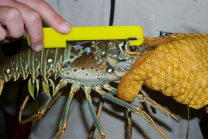
Local, state and federal agencies strictly enforce lobster harvesting and boating safety regulations in the Florida Keys during the lobster mini-season the last Wednesday and Thursday in July (July 26-27), and regular season that begins Aug. 6. Captain David Dipre of Florida Fish and Wildlife Conservation Commission discusses important points ...
The Florida Keys, a paradise for ocean enthusiasts and adventure seekers, has once again set the stage for an adrenaline-pumping and unforgettable experience – the 2023 Florida Keys Sport Lobster Season. This much-anticipated event draws thousands of divers and snorkelers from all over the world, eager to catch a glimpse ...
Starting in March 2013, recreational crab traps in Florida will be required to have rigid funnel openings no larger than 2 x 6 inches at the narrowest point or 2 x 6-inch bycatch reduction devices installed to reduce accidental trapping of diamondback terrapins, which has been a significant threat to ...
The Florida Keys have a rich history dating back to the indigenous peoples who lived there thousands of years ago. Some of the most significant Florida Keys Historical Events include: Ponce de León's arrival in 1513: Juan Ponce de León arrived in Florida in 1513, marking the start of European ...
Are you looking for some fun and affordable things to do with your family in the Florida Keys? Look no further! Here are some great ideas for your next family vacation: Visit the Florida Keys Eco-Discovery Center. This museum is filled with interactive exhibits that teach visitors about the unique ...
Located at the southernmost tip of the state, the Florida Keys are a true paradise for anglers of all skill levels. With its crystal clear waters and diverse marine life, the Keys offer some of the best fishing in the world. Whether you're an experienced angler looking to target your ...
I am always looking for ways to save money while still being able to enjoy all the activities and experiences that a place has to offer. That's why I was excited to discover that the Florida Keys have plenty of opportunities for free shoreline fishing. Whether you are an experienced ...
Pages